|
Historia
Kyrksundet
i Hitis, SV Finland.
Av
Torsten Edgren
Finns
för tillfället bara på engelska.
A
Viking Age resting place and trading
post on the sailing route to
the East.
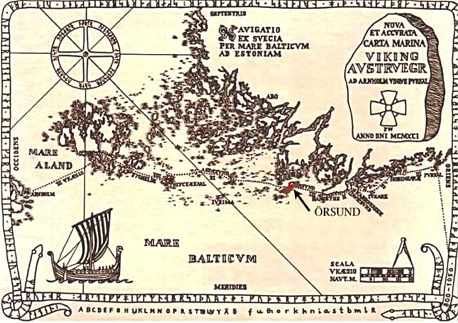
One of the oldest written sources dealing with the
archipelago in south-western Finland is a description of a sailing route,
generally referred to as "the Danish itinerary". The manuscript
is part of the Codex ex Holmiensis A
41, also called "King Waldemars land register", Liber census daniae, a Latin copy, which describes the route from
Utlängan in south-eastern Blekinge along the east coast of Sweden up to
Arnholm in Roslagen, from there over Åland's sea to Lemböte near
Mariehamn, and further on via Föglö, Kökar, Aspö and Hangö (Hangethe),
the southernmost point of Mainland Finland. From there you could cross The
Gulf of Finland by sailing directly or via Porkala Peninsula further to
the east to "Raeuelburgh", that means Tallinn in Estonia.
Despite its name, the itinerary is, however, not a true
description of a route which contains sufficiently precise information
about distances and directions that could be used in problem-free
navigating. It rather provides an account of the general route through the
outer archipelago and register resting places and harbours which were
available during early medieval times. People travelled during the day in
the shelter of the wide, and as far as navigating is concerned, rather
complicated archipelago and overnighted in sheltered harbours. During
stormy days and in bad weather conditions the stay could be extended for
several days.
It has also been stressed that the Itinerary enumerates
inhabited places where the Fransiscans were in action. The dating of the
document seams to be early 14th Century.
However, it can be noted that most of the areas referred
to in the itinerary, were good harbours for the relatively small shallow
and easily navigable ships of those days. In some of these harbours
chapels where you could pray and, if necessary, be buried, were later
erected by early missionaries. Towards the end of the 14th Century only
few of the resting places were replaced by real harbours which could
accommodate larger and more deep going cargo vessels, most of them were
forgotten. At the same time some of the routes were changed to deeper
waters.
Archaeological investigations related to the itinerary
have earlier been carried out
only in exceptional cases at the end of
the 1930-ties, the research activities in connection with the
harbours of Finland in the Viking and the Middle Ages being more
concentrated on historical sources and studies related to place names. The
only exceptions of extensive research are those carried out by Kenneth
Gustavsson on Hamnö in Kökar on the Åland Islands- one of
the places mentioned in the itinerary - and my own excavations in
the 1970-ties on the island of Jurmo, which is also referred to in the
itinerary and on Högholmen in Hitis, a little fortified island site close
to Kyrksundet.
Kyrksundet
in Hitis
According to the itinerary there is in other words a
reference to a place called Örsund being situated between Aspö and Hangö.
Such a name is not amongst those currently used. It can however clearly be
demonstrated that Örsund refers to Kyrksundet in Hitis, a place which
appears in written sources for the first time in August 1347 when the
Swedish king Magnus Eriksson visited the place on a trip to Finland. He
signed two letters in ”Kirkiusundz”.
The place name Kyrksundet was not restricted only to the narrow
sound and the bay between the islands Rosala and Hitis, but covers a
larger area called Kyrkosundsskär, nowadays
the parish of Dragsfjärd. It is obvious that King Magnus visited Högholmen
outside the village of Hitis where you can find jetties dated by
dendrochronology to the 14th Century.
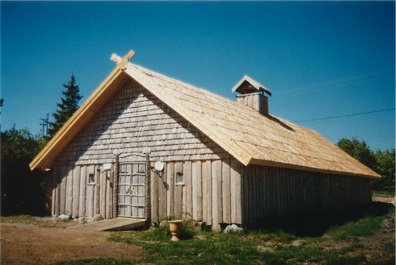
The Chapel
At Kyrksundet in Hitis there are some remains of a
rejected chapel, visited already in 1871 by early antiquarians. The area
was investigated in 1938 and 1939 and also 1993 - 1997. The chapel is
surrounded by a 35 x 30 m stone wall. Between the chapel and the
surrounding wall several graves has been excavated.
The find material consist mainly of coins - some
50 are found -. which
well correlates with the history of settlement and trade in the area. The
oldest graves so far can by radiocarbon be dated to the second half of the
12th Century. The chapel was abandoned in the beginning of the 17th
century and a new church was erected in the village of Hitis in 1637.
"The
Viking Age harbour or resting place" at Kyrksundet
In 1990 a collection of Viking Age items was discovered
with a metal detector in the immediate neighborhood of the chapel ruins,
dating the resting place / harbour of the itinerary already to the Viking
Age. Excavations, although only on a limited scale, have been carried out
during the summers 1992 – 1997, but only some 400 m2 of
perhaps 40 000 m2 have
up to now been excavated. Prospecting of the area with metal detector
indicates, that there are thinly but clear signs of human activity along
the northern shore of the sound along a stretch of at least some 550 m,
but no building constructions, not even simple pit houses, have been
observed. Pottery is rare on the site. A fragment from a rough clay pot
comes from a Slavic or Vendish pot imported in the 12th Century or even
earlier from the south coast of the Baltic sea. Some pots of the same type
are found on the sea bottom near Purunpää a few miles further to the
north. Underwater archaeological investigations in Kyrksundet shows that
there are no remains of posts and jetties.
This fact can be of chronological significance in that they are
also absent from the Viking age harbours of Gotland - the so called
"lagoon" harbours of which Paviken is a good example
The only indication so far of people living on the site
is a very dark and soothy culture layer found in 1995 at a distance
of 150 m from the chapel It
was situated in a low concavity in the rock and covered some 25-30 square
meters. It can best be
interpreted as the remains of a workshop. The finds includes bronze bars
and scrap metal for casting , a matrise of slate for the production of
thin ornamented metal folios, raw glass, glass and mosaic beads, small
whetstones, a spinning whorl of clay, amber, iron ship rivets and small
pieces of silver probably for the production of jewellery. The majority of
these pieces are tiny fragments of silver coins, mostly Anglo - Saxon
struck during the reign of Ethelred II (978-1016) or German like
Otto Adelheid pennies (983-1040) or frisian minted by Bishop Konrad I
(1076-99) in Deventer and Egbert II (1068-90) in Dokkum just to name some
examples. The workshop seems to have been in operation at the end of the
11th Century. As there are more examples on bronze casting among the finds
from Kyrksundet it is obvious, that bronze technology was an important
activity for the people living on
the site. Casting moulds have so far not been found.
A large number of metal objects have been found during
the investigations in Kyrksundet, the majority of them being
collected in connection with a systematic prospecting of the area
east of the chapel ruins with a metal detector. It has been possible to localize and
collect bronze items, which may otherwise not have been noticed in the
rough and very hard packed moraine. This applies, for example, to small
droplets of bronze, originating from casting, and to the small pieces of
silver coins from the workshop. Despite the rather systematic prospecting,
our knowledge of some of the important parts of the area is still limited.
Of the coins collected on the site outside the workshop
mention should be made of fragments of half a dozen of Samanid dirhems. Of
these coins the oldest is struck in North Africa already in the 8th
Century, two were minted by Ismail ibn Ahmad in Andaraba (892-908), while
a third is an imitation of a Tashkent struck dirhem, probably from the
Volga-bolgarers area and dated to the 10th century, all well known types
from Finnish and Scandinavian Viking age hoards. There are also German
coins, minted by Otto III during his caesar period (996-1002) as well as
some German Sachsenpfennig from the end of the 10th
Century. Some Anglo-Saxon coins are also present. In a similar
manner to the above-mentioned coins being connected with trading, there
are also more then twenty loads or weights which were found scattered
around the area. The material includes both small polyeder-shaped weights
of bronze and iron weights with and without bronze covers and all kind of
dots marking their weight. Included in this category of finds related with
trade is a gold and silver plated philigree bead of bronze.
Among the finds of personal ornaments are several
penannular brooches of bronze, some of them of
rare Gotlandic types, and a bracelet with long thin outdrawn ends
and a lancet-shaped plate decorated with circles, of a type which appears
in central Sweden, while a large ring brooch or pin actually represents a
western Scandinavian form. Three bronze key shafts, of a shape which has
been found e.g. in Birka in
Central Sweden, but most frequently in 10th Century graves on Gotland are of special interest and unique in Finland, while a
key-shaped pendant with attached chain has a counterpart among finds from
the Province of Häme. This pendant represents a domestic type. A small
bronze fragment originates from the outer surface of a Scandinavian
oval-shaped brooch, a trefoil brooch is Scandinavian too as is a fragment
of a guilt ringed pin, while a comb-shaped chain divider and a comb-shaped
pendant with tin ornamentation represents Baltic and domestic forms. A
west Finnish round convex broche of Appelgrens type B belonging to the
woman's dress can be dated to the beginning of the 9th Century. It was
found hidden between two boulders together with bronze spirals from a
belt.
The iron objects are usually badly corroded except for a
heavy axe typical for the Viking age and our knowledge on the use of iron
and iron production on the site is therefore sparse. Also Iron slag is
nearly unknown on the site. A well preserved
sword of Petersens type H/I with a magnificent pommel with silver
inlays has however been
found.
Regarding the jewellery, it can be noticed that several
fragments from heavy bronze bracelets have been chopped with a chisel to
return them to raw material; they have in other words been recycled. If
they had been collected from a Finnish cremation flat cemetery, of which
we have examples from elsewhere, they should have a patina caused by fire.
As this is, however, not the case, they must come from inhumation graves
or, more likely, from military looting expeditions carried out to northern
Estonia. Several bracelets represent Estonian types. In addition to scrap
bronze, the material contains several bronze bars of Viking age type.
Harbour,
trading place or outer archipelago settlement
The majority of the above-mentioned archaeological artifacts
can be dated to 800-1100, which indicates that Kyrksundet was frequently
visited long before the first chapel was erected at he site and long
before the route was described in the Itinerary.
It is obvious that the site which still lacks a typical
culture layer and distinct man made structures is more complex than was
originally thought. It seems for instance that some archaeological
observations can shed new light on the interesting question of the origin
of the place name Hitis,
derived from the the Finnish word hiisi,
which refers to an "offering site" or "holy grove"
and is an example of the many Finnish place names found in the archipelago
of Finland Proper. In the center of the site and close to some large
boulders, a sword, a spear, a chain-holder broken into pieces,
the already mentioned Finnish convex round brooch and a dress pin
decorated with a bulls head were found. The ornaments were discovered in
only slightly coloured - but not sooty - soil several meters from each
other, whilst the weapons lay in an area of perfectly clean sand. As no
burned or unburned bones were found to indicate that a body was buried
there, none of the objects can be said to originate from a grave. The
round brooch seems moreover to have been bound with a thread ornamented
with bronze spirals and then hidden under a stone slab. These objects can
perhaps be interpreted as gifts to the Hiisi, one of the gods of the forest according to Mikael Agricola in
his list of old Finnish heathen gods included in the first translation of
the bible into Finnish in 1542 - "Hiisi
Metzeleist soi woiton" which means "Hiisi was the one to
provide game". It is obvious that the site at Kyrksundet already in the 9th Century had religious in addition to
mercantile significance.
One should also recall that in the sagas of both Njál
and St Olav the coastline of Southern Finland is called "Balagårdssidan".
The name obviously refers to the custom of lightning fires on high rocks
to warn the population against the Vikings attack.
In the saga of St.Olav you can read how Olav sailed to
Finland after returning from a plundering expedition to Eysyssla (Saaremaa,
Ösel in swed.,in Estonia):
Then he sailed to Finland, went ashore and embarked on
destruction, but all the inhabitants escaped in the forest, taking along
with them all their belongings from the area. The king went far inland and
through some forests: there were some valley district called Herdalar.
They took some property but captured no men. At dusk the king returned to
the ships. But when they entered the forest, people gathered from all
directions to meet them, they were shot at and severely harassed. The king
told his men to seek shelter, but before he found his way out of the
forest he had lost many men and many more were injured. He reached the
ships in the evening. At night the Finns raised a storm in the sea with
their spells. But the king ordered the anchors to be weighed
and set the sails; they tacked along the shoreline in the night. The king´s
good luck was then, as often, more effective than the spells of the Finns.
During the night they managed to tack along the coast of Balagård and out
to sea. But the Finnish troops followed by land as the king sailed along
the coast.
If one consider that the archipelago is ecologically one
of the most productive zones of the country, with excellent shore
pastures, waters teeming with fish and possibilities for seal hunting, it
is natural that the inhabitants of the coast and the inner archipelago
made the most of these resources, at least on a seasonal basis. The silver
coins and weights indicate that people also traded,
and the many examples of bronze casting indicate that there were
also craftsmen present. If one consider that the sailing season after all
is rather short - maybe from early May to mid October - it appears likely
that living in Hitis was tied to the seasons.
In such a case one can assume that Kyrksundet was inhabited by
people from iron age farms to the north in Halikko, Kemiö and Bjärnå,
who during the summer moved south to the eastern route and traded with
travellers and benefited from the favourable economical conditions of that
time. This trade was more international during the 11th and 12th centuries
than in previous centuries as reflected in the rich grave finds from those
regions. Gradually there was a need for more permanent facilities for the
travellers which led to a more stabile settlement. The spinning whorl
clearly indicates that also women were present on the Kyrksundet -site.
The examples of bronze casting mentioned above, together
with the important workshop find, suggest that itinerant craftsmen
gradually established themselves in the vicinity of the sound, thereby
giving the settlement a more permanent character. This led also to the
need of a cemetery, which was established in the same location where the
medieval chapel was later raised. It is not impossible that these events
might reflect the first stages of that Swedish colonization of the
southwest Finnish coast which came to dominate the following decades. On
the other hand, immigrants and transients from all directions may have
gradually formed the basis of a multiethnic population as happened for
instance in Staraja Ladoga.
An important find related to the settlement in Hitis is a
find of a fragment of a Scandinavian rune stone, the only so far
found in Finland. The ornamented stone was found in a sheltered bay but
despite underwater archaeological prospecting on the find spot it is still
an open question how it got there. It is not out of question that the
stone may have belonged to a ships ballast. Of the fragmentary text you
only can reed a mans name torfast.
There are good reasons to believe that most of the
Scandinavian seafarers on their way to Gårdarike, Aldeigjuborg, Holmgård,
and the big Russian rivers leading to Miklagård and the eastern
Mediterranian world used the route described, spent a day or two in the
harbour of Kyrksundet and left all kind of trading goods behind them. But
on the contrary there are only few finds of eastern origin in Kyrksundet.
Perhaps the seafarers found it wise to take an outer route on their way
home, just to avoid looting Finns and save their luxury goods for their
people at home. On the other hand it is a common trend that the eastern
trade gradually diminished in the 11th Century.
According to historical sources, the interaction between
the outer archipelago and the settlement located in the protected bays of
the mainland further to the north continued into the 17th
Century, when people from Halikko seined for Baltic herring on the islands
west of Hitis. As we can see this
interaction has ancient roots.
The fluorishing economy in Viking Age Finland cannot as a
whole be explained solely
through foreign contacts and trade relationships. On the contrary, the
changes appear to emanate from a domestic economical evolution, which
included e.g. a definitive shift to permanent fields (as opposed to
shifting swiddens) and the birth of village communities. At the same time,
it is apparent that the rise in the standard of living affected an ever
larger portion of the population. Viking Age grave finds point to an
egalitarian society of the type that usually characterizes affluent
farming communities. None of the graves differ from the others – whether
in construction, location or grave goods – to the extent that they could
be thought of as belonging to leaders with exclusive political power. This
does not mean, of course, that there were no affluent landowners or
merchants who could afford to buy expensive
swords, nor indeed paupers and slaves.
|